This image is an image that I found off of Google depicting many road signs in britain.
I also researched some funny road signs and I came across a photo on Google that I recreated in photoshop.
I recreated the image because the photo that I found wasn not very clear.
I recreated the image because the photo that I found wasn not very clear.
I thought to also research some funny signs, because there may be some humour in the way signs are placed or read in my game. This is something I have not yet decided.
This is a sign that I created in photoshop for my game.
This sign is a directional sign and will be used as a clue.
This sign is a directional sign and will be used as a clue.
I did it in this style because I think that it is very natural colours. I blured out the background becaus I wanted to show some depth of field. I think this is effective for close-ups in the game because it helps to focus on the main points.
This image is a guide to the meaning of the shapes and colours of road signs. This was helpful for me in my reserach of road signs.
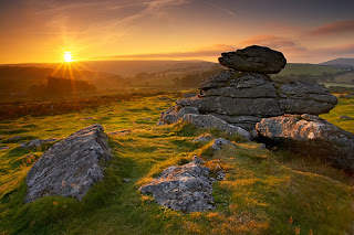
Dartmoor Research.

Image found here.
Dartmoor is an area of moorland in south Devon, England. Protected by National Park status, it covers 954 square kilometres.
Parts of Dartmoor have been used as military firing ranges for over 200 years. The public enjoy extensive access rights to Dartmoor (including restricted access to the firing ranges) and it is a popular tourist destination. The organisation responsible for tourism on Dartmoor is the Dartmoor Partnership.
Information found here.
At 368 square miles (954 sq km) in area Dartmoor is the largest upland in southern Britain. Millions of people visit it each year for its dramatic landscapes, varied habitats and wildlife, and cultural heritage. There are some 17,500 protected archaeological remains dating from the bronze age, through the medieval period right up to a recent industrial past. Dartmoor was designated a National Park in 1951.
Information found here.
Here is a video that I found on YouTube, Portraying the nature of Dartmoor.

These are images I found on the internet based in the Moors being haunted by Piskies.. Which are another name for fairies or pixies.
Dartmoor Research.

Image found here.
Dartmoor is an area of moorland in south Devon, England. Protected by National Park status, it covers 954 square kilometres.
Parts of Dartmoor have been used as military firing ranges for over 200 years. The public enjoy extensive access rights to Dartmoor (including restricted access to the firing ranges) and it is a popular tourist destination. The organisation responsible for tourism on Dartmoor is the Dartmoor Partnership.
Information found here.
At 368 square miles (954 sq km) in area Dartmoor is the largest upland in southern Britain. Millions of people visit it each year for its dramatic landscapes, varied habitats and wildlife, and cultural heritage. There are some 17,500 protected archaeological remains dating from the bronze age, through the medieval period right up to a recent industrial past. Dartmoor was designated a National Park in 1951.
Information found here.
Here is a video that I found on YouTube, Portraying the nature of Dartmoor.
These are images I found on the internet based in the Moors being haunted by Piskies.. Which are another name for fairies or pixies.
|
|
|


No comments:
Post a Comment